Jeanne still may imperil East Coast
- Share via
MIAMI — Deadly Hurricane Jeanne could head back toward the United States and threaten the storm-battered southeast coast, including Florida, as early as this weekend, forecasters said Wednesday.
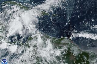
It was too soon to tell where or if Jeanne would hit, but forecasters at the National Hurricane Center in Miami warned residents from Florida to Maryland to watch the storm with 90 mph top sustained winds.
At 11 p.m. today, Jeanne was centered about 485 miles east of Great Abaco Island in the Bahamas. It was moving west-southwest near 5 mph and was expected to turn west.
“The new forecast track increases the threat to the southeastern coast,” said hurricane specialist Jack Beven.
Some computer models had the storm curving out to sea and missing land, but others had it hitting the United States on Saturday or Sunday, forecasters said.
Residents in the northwest and central Bahamas were also at risk, forecasters said.
Jeanne was blamed for more than 700 deaths in Haiti, where it hit over the weekend as a tropical storm and caused flooding. It had been moving out to sea, but it appeared to be looping back toward land, forecasters said.
Dangerous surf and rip currents along with large swells are possible along the southeastern U.S. coast over the next few days, forecasters said. If Jeanne hit Florida, it would follow Hurricanes Charley, Frances and Ivan, which caused billions of dollars of damage and more than 60 deaths across the state.
Meanwhile, remnants of Hurricane Ivan developed into a tropical depression in the Gulf of Mexico, prompting tropical storm warnings in Louisiana and Texas. Though most of Ivan broke apart days after the storm barreled onto land, one part circled southward and crossed Florida, dropping 1 to 2 inches of rain on parts of the state.
The National Weather Service said the depression, which had sustained winds of 35 mph, was about 155 miles south of the mouth of the Mississippi River, and was likely to strengthen into a tropical storm by the time it makes landfall late in the week.
Systems with sustained winds of at least 39 mph are classified as tropical storms.
Farther from land, Hurricane Karl weakened and stayed on an open-ocean course that only threatened ships, while Tropical Storm Lisa moved slowly far out in the Atlantic.
Karl, the seventh hurricane this season, had top sustained winds near 105 mph, down from about 120 mph a day earlier. At 5 p.m., Karl was centered about 1,400 miles west-southwest of the Azores and was moving north near 16 mph.
At 5 p.m., Lisa had top sustained winds near 50 mph, down from about 70 mph a day earlier.
The 12th named storm of the season was centered about 1,205 miles west of the Cape Verde islands and was moving west-southwest near 6 mph.
Residents in the northeastern Caribbean should monitor Lisa, which was heading in their general direction although it was still about a week away. Lisa could also follow Karl north on a path far away from land, said Eric Blake, a meteorologist at the hurricane center.
The hurricane season ends Nov. 30.
More to Read
Sign up for Essential California
The most important California stories and recommendations in your inbox every morning.
You may occasionally receive promotional content from the Los Angeles Times.


